|
- 'The Netherlands' actually means lowlands, and that description is
a good one as it's very much on and in the water. Without the dykes
and protective systems, almost half the country would be submerged!
In fact, there's a Dutch saying: 'God made the earth but the Dutch made
Holland.'
- Today about 27 percent of The Netherlands is below sea level, and
sixty percent of the population (six out of ten Dutch people) live there.
This below-sea-level area includes the cities of Amsterdam, Rotterdam,
Haarlem, The Hague and Delft, which explains why flooding is the biggest
threat the Dutch face from nature.
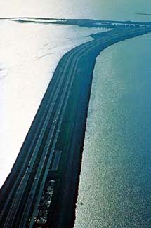
This is the Afsluitdijk barrier. As you
can see, it's also a road! On the map, it's that blue line across the
water just below the 'W' in Waddenzee.
Photo: Minbuza.
|
 |
|
Interesting Facts:
- The highest point in The Netherlands is 321 meters (that's 1,053 feet).
The Dutch call it a 'mountain'. See if you can find it on the map. Hint:
It's not at all near the North Sea!
- For a map that shows the physical layout of The Netherlands and just
how low the 'lowlands' are, go to NationalGeographic.com.
Once there, you can zoom in and out and move around to get a better
view.
- Lowest point: Prins Alexanderpolder near The Hague is 7 m (23 feet)
below sea level. That means that it's tied with a place in Denmark
for the lowest point in western Europe.
Source: Geography.about.com
|
- Terpen and dykes are ways that the Dutch have held back
the sea for more than 2000 years, since the area was first peopled by
Frisians. There are now more than 2,400 km (about 1,500 miles) of dykes.
- The reclaimed land areas are called polders. Canals and pumps
keep the water out. Windmills used to provide power for the pumping,
but now most pumps are electric.
- In 1287 the terpen and dykes that held back the North Sea failed,
and water flooded the country. A new bay, called Zuiderzee (South Sea)
was created over former farmland. Since then, reclaiming this land has
been an ongoing project.
- The Netherlands is growing in area without adding land from its neighbors,
Germany and Belgium. How? In 1986 the new Dutch province of Flevoland
was created, and it's made up of entirely reclaimed land. For more information
about polders and dykes, check out this article.
- The collective North Sea Protective Works is one of the Seven Wonders
of the Modern World, according to the American Society of Civil Engineers.
|
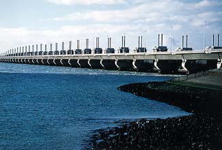 Here's
a part of that protective shield: Here's
a part of that protective shield:
the Delta Storm Surge Barrier.
Photo: Minbuza.
|
|
Location:
On the northwest corner of continental Europe with the North Sea to the
north and west, Germany to the east and Belgium to the south. The Dutch
coastline is 451 km (280 miles). The border with Germany is 577 km (359
miles) and the border with Belgium is 450 km (280 miles).
Besides being on the coast, The Netherlands is also at the mouth of rivers
— the Rhine (de Rijn), Waal, Maas, Ijssel and Schelde Rivers. These
rivers also allow seagoing ships to get to places in Belgium and Germany
traveling through The Netherlands.
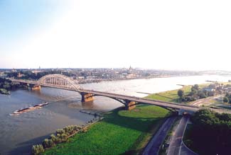
Bridges and barges... this is on the Rhine
River.
Photo: Minbuza.
|
 |
|
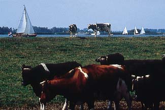 This
is a scene in Friesland, where there truly are more cows than there are
people! If you look at the cows back near the edge of the lake, you can
see that they're the tallest things on the land. This
is a scene in Friesland, where there truly are more cows than there are
people! If you look at the cows back near the edge of the lake, you can
see that they're the tallest things on the land.
Photo: Minbuza.
|
Landscape:
The Netherlands is mostly coastal lowland and reclaimed land (polders).
In the southeast, the land is higher and there are some hills. It's been
said that the highest things in The Netherlands are the cows!
Sources: Maps.com
and NationalGeographic.com.
Another place to find more info is Atlapedia.com
|